Route: Swiftcurrent Trailhead (Many Glacier) → Fishercap Lake → Redrock Falls → Bullhead Lake → Swiftcurrent Pass headwall (turnaround ~6 mi, just below the pass)
Distance: ~12 miles round trip
Type: Day hike
Elevation: 4,960 ft trailhead → ~7,000 ft turnaround (pass is 7,185 ft at 6.9 mi)
Date hiked: May 24, 2026
Conditions: Early season — bare and pleasant down low, continuous steep snowfields on the upper headwall
Permit: None for day hiking (a Many Glacier vehicle reservation may apply in peak summer — check current NPS rules)
Swiftcurrent Pass is one of the great walk-up passes in Glacier National Park. From the Many Glacier valley you climb past a chain of lakes and a waterfall to a 7,185-foot saddle on the Continental Divide, with the Swiftcurrent Lookout perched another 1,200 feet above and the Granite Park Chalet and Highline Trail waiting on the far side. In July and August it’s a bucket-list day hike.
On May 24th, it is a different mountain. I went in knowing it would be early — and the lower trail was glorious — but the upper headwall was still buried in steep, hard spring snow. I made it to roughly the 6-mile mark, close enough to see the top, before a snowfield I wasn’t willing to cross turned me around. Here’s the honest account.
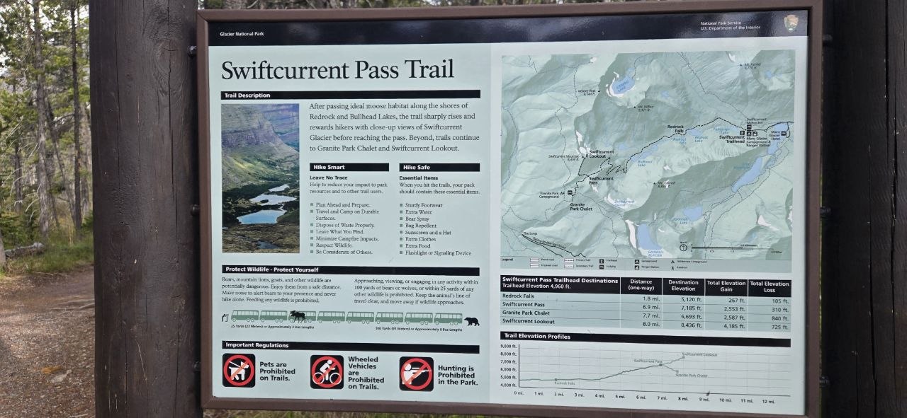 The NPS trailhead sign lays out the whole route — and the numbers worth knowing before you start.
By the Numbers (from the NPS trailhead sign)
| Destination | Distance (one-way) | Elevation | Total Gain | Total Loss |
|---|---|---|---|---|
| Redrock Falls | 1.8 mi | 5,120 ft | 267 ft | 105 ft |
| Swiftcurrent Pass | 6.9 mi | 7,185 ft | 2,553 ft | 310 ft |
| Granite Park Chalet | 7.7 mi | 6,693 ft | 2,587 ft | 840 ft |
| Swiftcurrent Lookout | 8.0 mi | 8,436 ft | 4,185 ft | 725 ft |
Trailhead elevation: 4,960 ft. The takeaway: it’s a gentle grade for the first ~4 miles, then the headwall does almost all of the work in the final push to the pass.
Getting There: Many Glacier
The trail starts at the Swiftcurrent Trailhead near the Swiftcurrent Motor Inn at the end of the Many Glacier Road. Many Glacier is the wildest-feeling developed corner of the park, and in late May it’s quiet — most of the summer infrastructure isn’t open yet and the crowds haven’t arrived. That solitude is a big part of why I wanted to go now.
A note on access: the Many Glacier Road is usually drivable by late May, but conditions and construction can change year to year. Check the NPS road status before you commit to the drive.
The Lower Trail: Easy, Beautiful, and a Little Wet
The first few miles are some of the most pleasant flat-ish hiking in the park. The trail rolls along the valley floor through open forest and meadow, mostly snow-free this time of year.
- Fishercap Lake sits just a few minutes from the trailhead and is one of the most reliable moose-viewing spots in all of Glacier — slow down, stay quiet, and scan the shallows and willows.
- Redrock Falls (1.8 miles) is a wide, tiered cascade over the park’s signature red argillite. A perfect snack stop.
- Bullhead Lake (around 3 miles) marks the end of the gentle valley walking. From here the headwall rears up and the real climbing — and the snow — begins.
One early-season heads-up: with all the snowmelt running off the high country, there are several stream crossings near the bottom of the climb, and unless you’re very careful with your footing on the stepping stones, you should expect to get your feet wet. Some crossings have a plank footbridge; others are a rock-hop. Quick-drying socks and shoes you don’t mind soaking make this a non-issue.
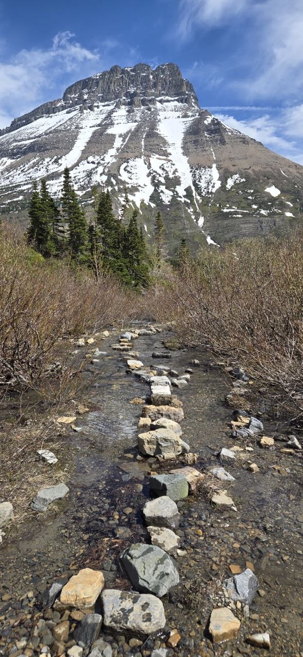 One of several snowmelt stream crossings near the base of the climb — careful footwork required, wet feet likely.
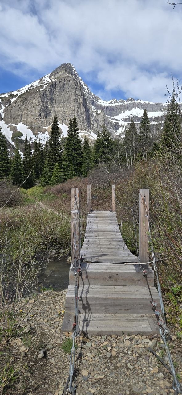 Where there’s a bridge, take it — the snowmelt was running high and cold in late May.
Wildlife
This whole valley is prime habitat, and the day delivered. I spotted deer down low and — the highlight — a mountain goat picking its way across the scree high on the headwall, perfectly at home on terrain that had me using both hands and trekking poles.
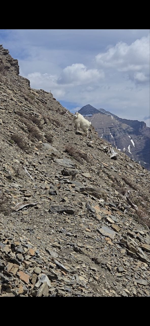 A mountain goat working the scree high on the pass — completely unbothered by the terrain that turned me around.
A serious note: this is also one of the densest grizzly populations in the lower 48. I carried bear spray accessible on my hip belt the entire day and made noise through the brushy sections. In Many Glacier, that’s not optional.
The Climb — Where the Snow Takes Over
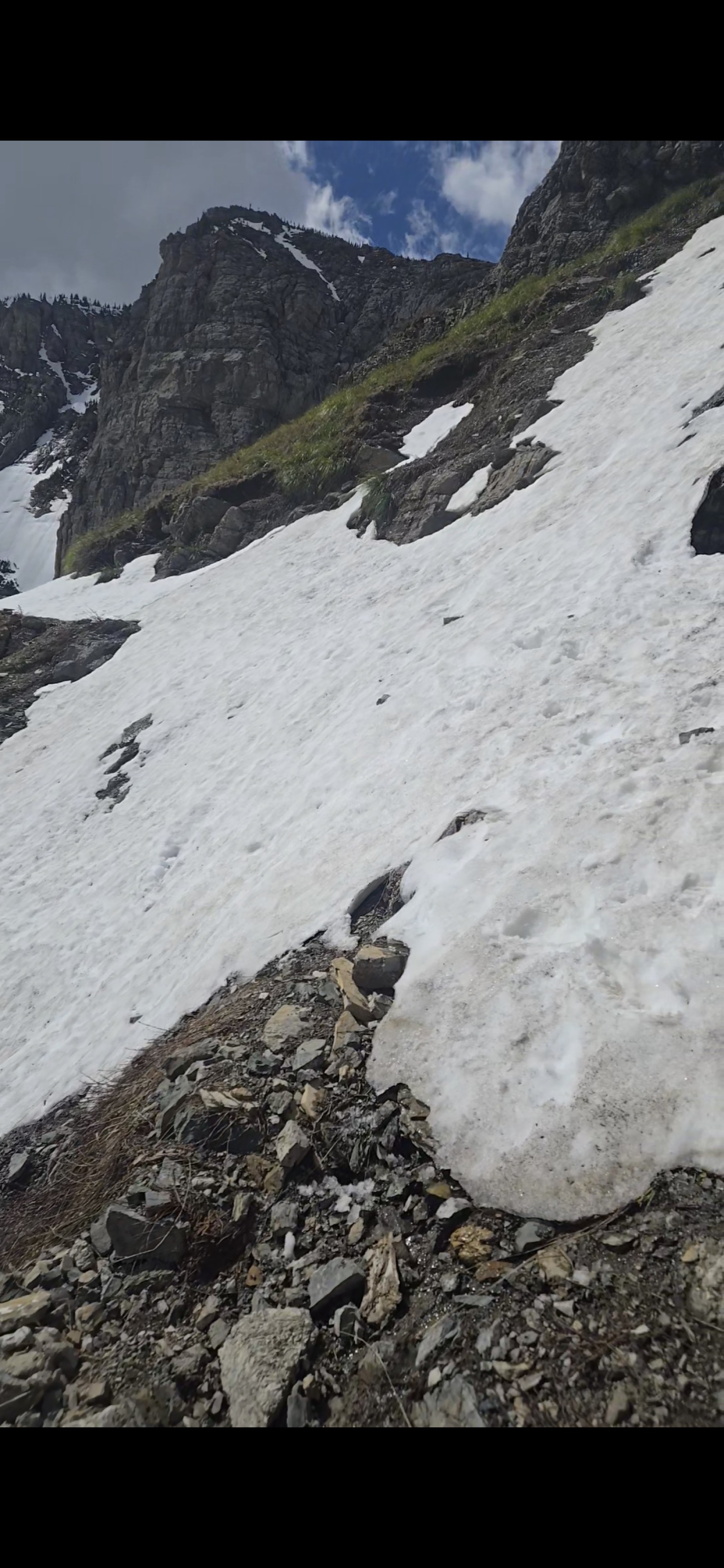
Past Bullhead Lake the trail switchbacks up the headwall toward the pass, and that’s where late May shows its teeth. The higher I climbed, the more the trail disappeared under continuous spring snowfields lying across steep, exposed terrain.
Here’s the key detail about the snow that day: the snowpack underneath was firm, but the top layer was very granular and loose because it was actively melting in the sun. Firm base, greasy surface — slick and treacherous, the worst kind of footing for a steep traverse. Trekking poles and ice cleats would be highly recommended. A slip on these slopes means a fast, uncontrolled slide toward rocks.
The Snowfield at ~5.5 Miles
 The snowfield at ~5.5 miles — passable, but only with traction, poles, and the experience to use them. A slip here has real consequences.
The first serious obstacle came at around the 5.5-mile mark: a steep snowfield draped across the trail beneath the cliffs. It is passable — I got across it — but I would not recommend it to anyone who isn’t comfortable on steep snow. With the right gear (traction and poles at minimum) and the expertise to move deliberately and self-arrest if needed, it’s doable. Without that, this is your turnaround.
The Turnaround at ~6 Miles
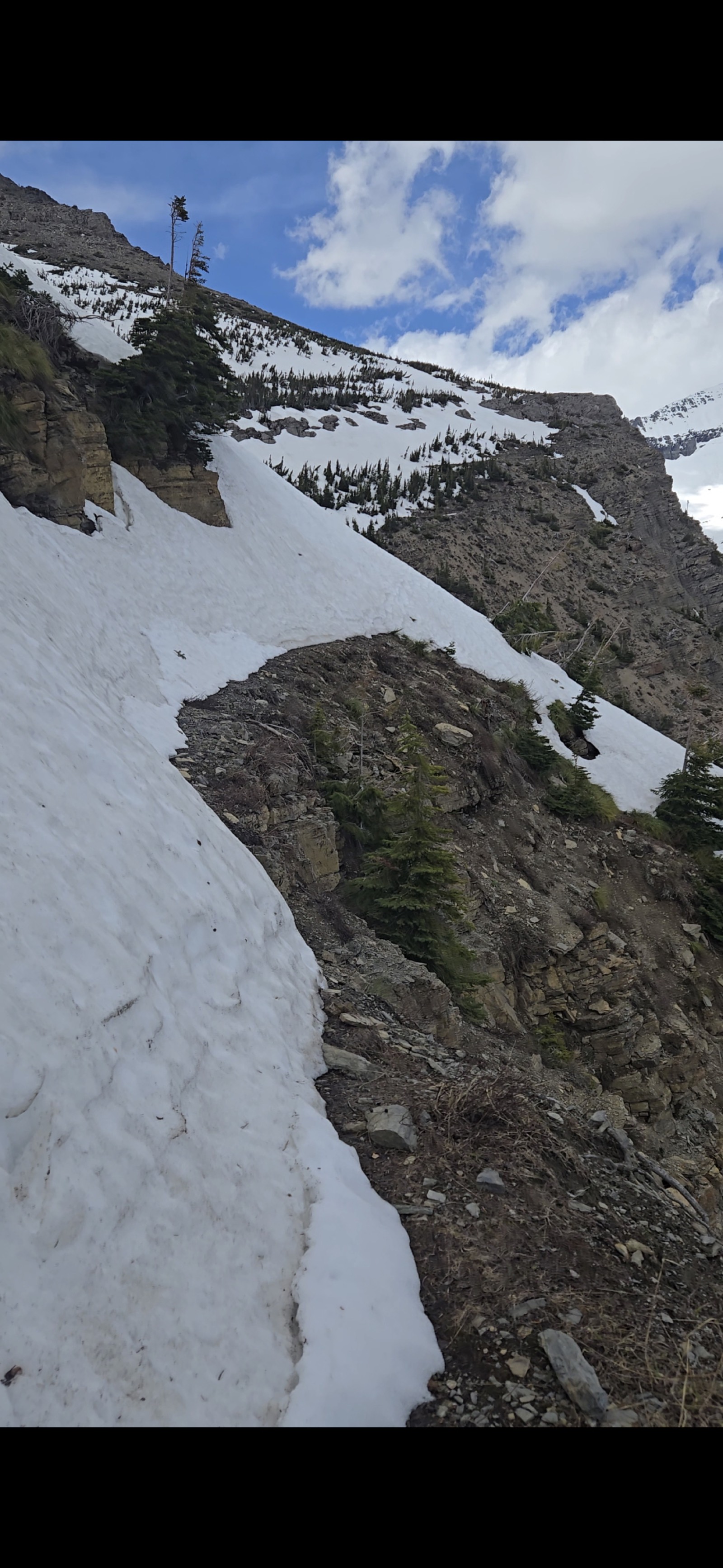 The turnaround at ~6 miles — a steep, exposed snow slope on a narrow ledge just below the pass. Too dangerous to cross safely. This is where I called it.
Maybe half a mile further, just below the top of the pass, the trail crossed an even steeper, more exposed snow slope clinging to a narrow ledge with a serious drop below it. This one I wasn’t willing to cross. The snow was hard underneath and rotten on top, the runout was bad, and the consequences of a slip were unacceptable for a solo day hiker. So close to the top — I could see where the trail topped out — but the mountain wasn’t offering safe passage that day.
Turning around that close to a summit is its own kind of hard. But the pass will be there in July. I won’t be if I make a bad call on a slope like that. I called it, downclimbed the snowfields carefully, and walked out.
The Views Up High Are Absolutely Incredible
Here’s the reward for the climb, and the reason to come back and finish it: if you can make it up to the top of the pass, the views are absolutely incredible. Even at my high point below the pass, the look back down the Swiftcurrent valley — the whole chain of lakes stacked toward the plains — stopped me in my tracks.
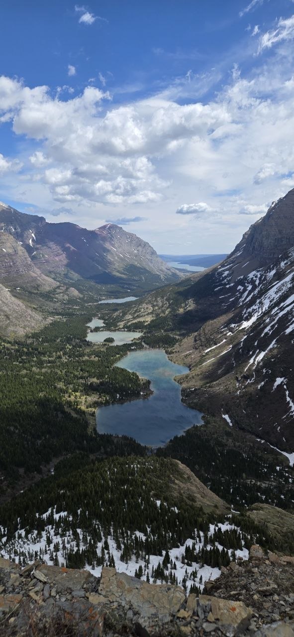 Looking back down the valley from high on the climb — the chain of lakes stacked all the way out toward the prairie.
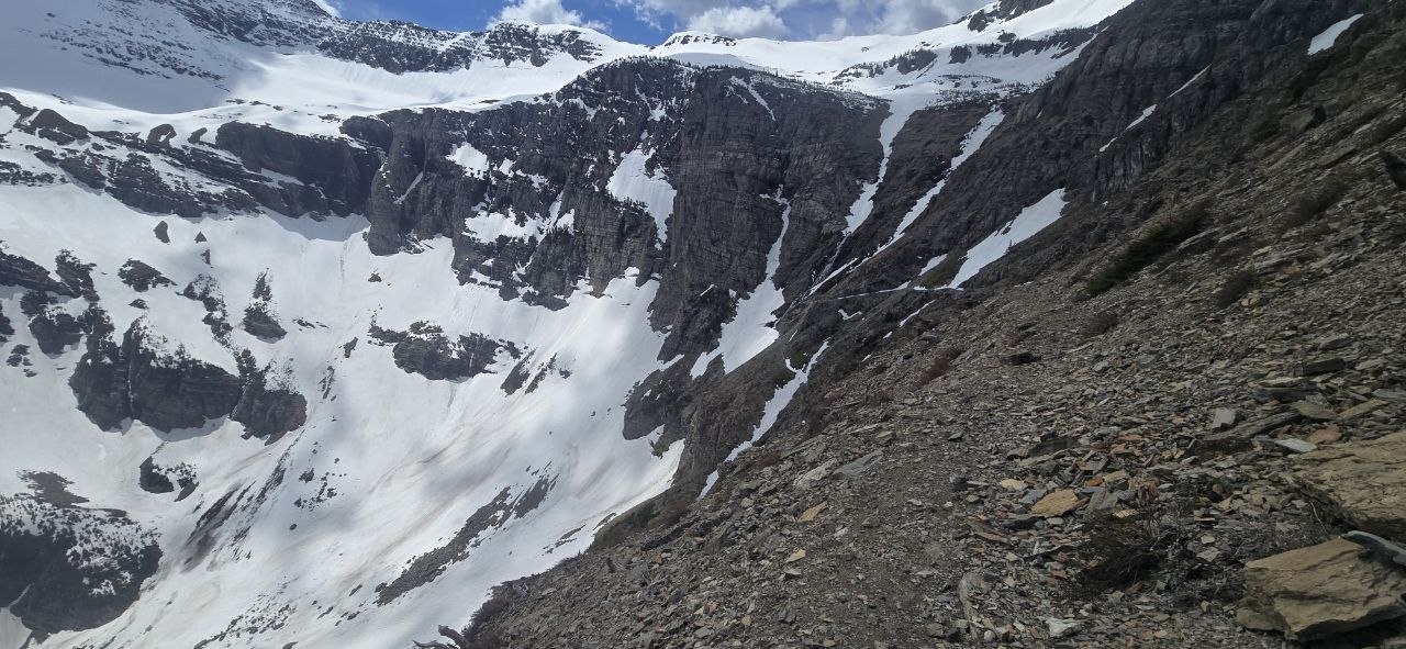 The snowy cirque below the pass — beautiful, and a clear picture of why the upper traverses demand respect this time of year.
What I Carried — A Light Day-Hike Kit
This was a fast, light day hike, and my kit reflected that:
- Backpack: Outdoor Products hydration daypack — simple, affordable, and plenty for a day on trail.
- Trekking poles: Atlas poles — see our best trekking poles guide (similar on Amazon). On the snowfields they were the difference between confident and sketchy.
- Water: 24 oz. Honestly on the light side for a warm climb — the abundant snowmelt streams make refilling easy, but bring a filter if you plan to.
- Fuel: Honey Stinger waffles and chews — easy, fast trail calories.
What I’d change next time: I did not have ice cleats on this hike, and I felt it on the upper snowfields. If I’m back this time of year, microspikes are the first thing in the pack — they’d have changed the calculation on that final snow slope. I’d also carry more than 24 oz of water on a warm day.
Conditions & Safety Notes
If you’re attempting Swiftcurrent Pass in the late-May / early-June window, take the snow seriously:
- Traction is essentially mandatory — microspikes/ice cleats at a minimum. The upper snowfields are firm underneath and slick on top as they melt.
- Trekking poles for balance on the traverses, and seriously consider an ice axe plus the training to self-arrest with it.
- Know your limits. “Doable with the right gear and expertise” is exactly the bar here. If steep, exposed, consolidated snow isn’t something you have real experience on, the upper mountain is not the place to learn it.
- Bear spray, accessible. Many Glacier is dense grizzly country.
- Start early and check the forecast — spring weather in Glacier turns fast.
Should You Go This Early?
If you want the full pass — the saddle, the Swiftcurrent Lookout, the drop to Granite Park — wait until midsummer, typically July onward, when the headwall melts out. What you trade for waiting is solitude and the strange beauty of a famous trail in its off-season silence.
But here’s the best part: this trail has something for everyone, no matter how far you go. Whether you climb high toward the pass or just wander the lakes and waterfalls down low, you’re going to have a great time and see incredible country. The bottom 3-4 miles are an easy, gorgeous walk that’s worth the trip on its own; the upper mountain is a genuine snow-travel objective that demands gear, skill, and the willingness to turn around. I’m glad I went. I’m also glad I turned back.
Bottom Line
- Lower trail (to Bullhead Lake, ~3 mi): easy, gorgeous, family-friendly even in late May. Moose at Fishercap, falls at Redrock, a few wet stream crossings.
- Upper headwall (past ~5 mi): serious early-season snow travel. Steep, exposed, consequential — bring traction.
- My day: ~12 miles round trip, turned around by an impassable snow slope at ~6 miles, just below the pass. Deer, a mountain goat, and unforgettable valley views.
- The call: the right one. The summit isn’t worth the slide.
More Glacier: Otokomi Lake — A Two-Season Trip Report · Glacier National Park: Best-Kept Secrets
Know the mountain. Respect the snow. Come home.
Get the Sub-10 lb Ultralight Gear Checklist
Join the free PackLite Life newsletter — new gear guides, trip reports, and trail-tested tips — and grab the printable checklist when you sign up. No spam, unsubscribe anytime.